Category Archives: Uncategorised

Corroboree Billabong – the Sony A9III in the field

The Doc took the Sony A9III out into the field for its first use. A few test photos on the ground at Bullo River Station, but the first proper test was the helicopter trip around the property. Report coming, with images, in due course.

With any new camera there is learning curve concerning how to best set it up and use it. A few mistakes were made and a few images lost, but no disaster. The Doc was worried at setting the frames per second (fps) too low in the helicopter, but the culling of images showed that not to be the case.

The camera can go up to 120 fps in High Plus speed mode. 120 fps was not used on the helicopter, but it was on the Corroboree Billabong cruise, when The Doc had limited time to get images, including the old saltwater crocodile. The camera was amazing and this feature will come in useful for action shots. You must use it sparingly and cull images cull images, hard.

Having visited Corroboree Billabong before with Wetland Cruises, The Doc knew it would be a good day trip out of Darwin. Corroboree Billabong has the highest concentration of crocs in the world. It has both fresh water and salt water crocodiles. Corroboree Billabong is located on the Mary River floodplain.

The landscape images were being taken by the Sony P&S, not the A9III, as the A9III was fitted with a 135mm lens.

The harsh light in the middle of the day meant no brilliant images from the billabong.

The roadtrains and billabong images first, followed by the crocs close ups.

Now the croc images. The croc was getting close to 5 metres in length, so very dangerous to the stupid and unwary.

Bullo River Gorge – lots of bull

The Doc is back in Darwin, sorting and culling images from the trip. He will spend a week here exploring, after a rest day.

If Bullo River Station sounds familiar it was made famous by Sarah Henderson’s book From Strength to Strength.

A superb all round experience. Amazing accommodation, great facilities, great food and support from both AWC Guides and Bullo River staff. The trip included bird watching, a morning river cruise, a guided helicopter trip, road trips around the Station and a last minute change in our arrival because of rain washing out the airstrip. We landed in Kununurra and were driven into Bullo River Station, down the Bullo River Access Road.

One place The Doc visited, on a helicopter trip around Bullo River Station, was Bullo River Gorge. More precisely, the part of the gorge known as Bull River Sands.

Earlier that morning, we had flown around the Bullo River and along the Victoria River to visit an AWC science team in the field, then we flew onto to Bullo River Gorge for breakfast.

The Bullo River starts and finishes on Bullo River Station, hence the Station’s name.

AWC runs the best supporter events, made even better when the Bull River Tourism team was involved.

A taste of what is coming. Enjoy.

Bullo River Sands, Bullo River Gorge, Bullo River Station

We were delivered in the bush taxi, a Robinson R44 helicopter landing in the gorge.

Bullo River Station: slight change of plans


There was rain overnight at Bullo River Station, so planes cannot land on the unsealed air strip. Guests are leaving earlier from Darwin and being taken to a nearby air strip – that would be a country “nearby”. Kununurra has the nearest sealed airstrip.

Then Guests have a 3 hour drive into Bullo River Station, which has the longest driveway in the Northern Territory. The driveway is the hard left off the Victoria Highway on the map below. All part of the adventure, for me. Plus The Doc knows how to drive into Bullo River Station in the Grenadier!

AWC just works around the challenges to get us there. Thank you AWC.

Exploring Bullo River Station: a journey to the Victoria Bonaparte Bio Region

The Doc is flying out to Darwin today. Next stop Bullo River Station, where Australian Wildlife Conservancy is hosting a Supporter’s Event, starting Wednesday. Thankfully AWC provides a high level of support, if needed.

Bullo River Station is near the headwaters of the Victoria River close to the Northern Territory and Western Australian border, sometimes called the Eastern Kimberleys. More accurately it is the Victoria Bonaparte Bio Region (named after the Victoria River and the Joseph Bonaparte Gulf, into which the Victoria River flows).

The Gulf is part of the larger Timor Sea. The Doc has not been this close to the coast in this part of Australia before, another first. He has only ever been well south around Timber Creek, Kununurra and Wyndham.

The Victoria River flows into the eastern side of the little-known Joseph Bonaparte Gulf, while the 5 Rivers up Wyndham way feed into the Cambridge Gulf on the western side of the Joseph Bonaparte Gulf.

Joseph Bonaparte was the older brother of the more famous Bonaparte.

Looking at satellite maps, there are many mud flats in this area, like Derby. Plenty of water in the wet season, plenty of mud down the river systems and mud flats everywhere! Plus, gorges, crocs and vegetation like the Kimberley.

It is nice to finally get away from all the intense rehab and treatment over the last 9 months. Upon my return The Doc needs to pick up the Vista RV Crossover hybrid van. Then more visits to Specialists and then, he hopes, to start traveling more widely again.

The above image was generated using AI, but The Doc hopes to make his own images during the visit.

EDIT: Now in Darwin and ready to fly out to Bulloo River Station tomorrow morning.

Derby helicopter trip – medium format style

The Doc also took his Pentax medium format camera on the helicopter. A selection of a few images from that camera are below.

The original images are massive in size (around 250 megs), and have stunning details even when heavily cropped. Not an easy camera to use in a helicopter because of its size and its slow autofocus. Plus you do not want to take too many images with large file sizes, which are slow and hard to work with. But the images, when they work out, are just gorgeous.

Click on an image to see the slideshow. It is worth it. Enjoy.

Plus some assorted images from Yampi Sound Training Ground, Charnley River Gorge up in The Artesian Range and the Buccaneer Archipelago.

Vista RV Crossover XLE

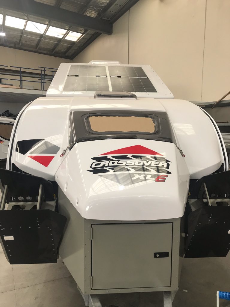
The Doc’s new hybrid offroad caravan is nearly ready – just a shelf to be made and installed. Photos were supplied today of the van.

Electrics controlled by a REDARC TVMS with the REDARC Rogue added on for more circuits. 645W of solar panels, 400Ah of Lithium batteries and a 3000W REDARC Black Alpha inverter. It has the air suspension option as well. Tyres match the Grenadier, BF Goodridge KO2’s. Plus red go fast stickers. External kitchen with a small internal kitchen. Fridge can be used internally and externally (it is on draw).

The model name XLE signifies external fridge, verse XLI for internal fridge.

The Doc will install his JOOCLA Shower into the van.

Enjoy (The Doc is!).

Derby mud flats

The massive tidal changes in King Sound reveals extensive mud flats across the southern part of the Sound, around Derby.

Derby township itself is surrounded by mud flats which The Doc drove on several times (being careful not to break through the dried surface). These mud flats are not fully tidal every day, probably only on King tides. However, anytime The Doc felt the surface get soft he headed back to drier parts.

After taking off, in the helicopter, the first place we see is the big house, the Derby Prison. The Prison inmates look after the graves at the nearby Leper Colony, aka the old Bungarun Leprosarium, just north of Derby (Blog report here). The Doc drove up to Bungarun using the mud flats, not the road.

The mud flats reveal one of nature’s fractals, the repeating patterns you see when water is draining away on the mud flats (what The Doc calls the recurring tree pattern). To be precise “Fractals are infinitely complex patterns that are self-similar across different scales.” If you look carefully, you will see the same pattern repeating itself. Admittedly it is more obvious in the helicopter where you better appreciate the scale of these fractals.

There is endless variety in the mud flats, including their shapes, colour and textures. While they are many images, the total was culled hard to give a good cross section.

The Doc finds the mud flats fascinating. Enjoy.

The Buccaneer Archipelago, with a little of Yampi Sound thrown in

Below is a satellite image of Derby, King Sound (that great big “harbour”) and on its northern edge a group of Islands known as the Buccaneer Archipelago. The Derby mud flats are obvious on the southern edge of King Sound, near the Derby township. Towards the top right is the Walcott Inlet, which leads into Charnley River and its gorge, yesterdays spectacular post.

The helicopter trip continues. Here is small selection of images from the Buccaneer Archipelago. Wikipedia states “The archipelago, covering over 50 square kilometres (19 sq mi) is located at the head of King Sound and is composed of about 800 islands found between King Sound and Collier Bay near Yampi Sound.”

Yampi Sound also has a major Army training base inland from the Sound itself. The images towards the middle with a burn off taking place, from memory, is part of Yampi training grounds. Often Yampi is boring open grasslands. The Australian Wildlife Conservancy helps the Army conserve part of the training grounds set aside for conservation along the coast.

The massive tidal flows are obvious in several images, with the disturbed water during a tidal change.

To see a larger image click on a thumbnail.

Charnley River Gorge, Artesian Range, The Kimberley

When posting some Kimberley images recently The Doc realised he has not posted images from his 2-day helicopter trip out of Derby in 2015 (better late than never!) – except 2 or 3 images.

Starting with Day 2, here are images from flying along the Charnley River Gorge, Artesian Range, The Kimberley, Western Australia. It was a thrill of a lifetime, breathtakingly beautiful place. We had permission from Australian Wildlife Conservancy to do the trip over their property and land. With both the pilot and the passenger being AWC supporters helps!

The Artesian Range is the only part of Australia that has not suffered any mammal extinctions since European settlement, but the cane toads got into the area in the last few years. So that may change.

Where the river bed is a muddy light grey, the river is tidal. The clearer water is beyond the tidal zone and is fresh water coming down the river.

We landed and took pictures of Aboriginal art, which had some very rare figures. The Doc may post one or two later.

Make sure you click on the image to see the full size slide show.

Grenadier Shift Cable bracket

The Doc has fitted a Low Range Shift Cable Support Bracket. Once fitted the cable will not hit or interfere with drive shaft. Install video here.