When Tony Stott and The Doc went on an adventure to the Flinders Ranges we visited Arkaroola Wilderness Sanctuary. One of the owners Doug Sprigg, loves to fly so we went on a flight over Lake Froome and the Flinders Ranges.
The Flinders Ranges is one of the most geologically unique places in the world. Geologists from all around the globe visit. There is an extraordinary variety of rocks twisted and bent by tectonic forces under the earth. For example, while driving in Brachina Gorge you drove over something like 700 million years of rock layers, that have been bent from the horizontal to the vertical.
One of The Doc’s favorite places to visit. Further south you have Wilpena Pound. Now back to the flight.
Tony had one camera (a Canon 5DII) and The Doc two (Canon 1DX and a Pentax 645Z), We sat on opposite sides of the plane to maximize our opportunities. When processing the images it became clear Tony often had the better side, as The Doc was often photographing into the sun. Together we got a nice mix of images.
Part 1 is below with the flight going out over Lake Froome. Lucky for us the Lake had some water still giving us extraordinary colours and textures. Lake Froome is apparently the whitest salt lake in the world and used by NASA to take various measurements.
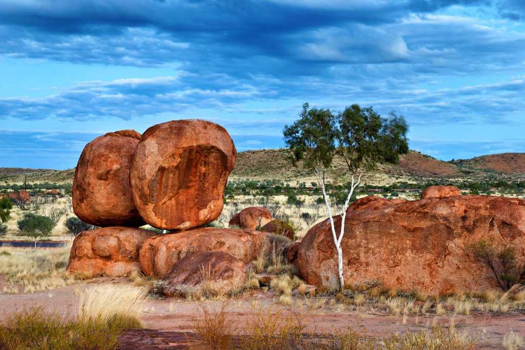
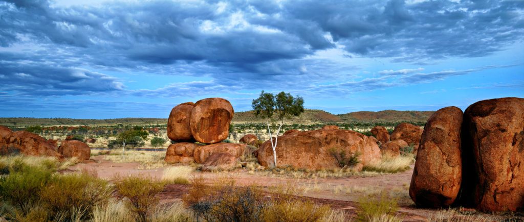
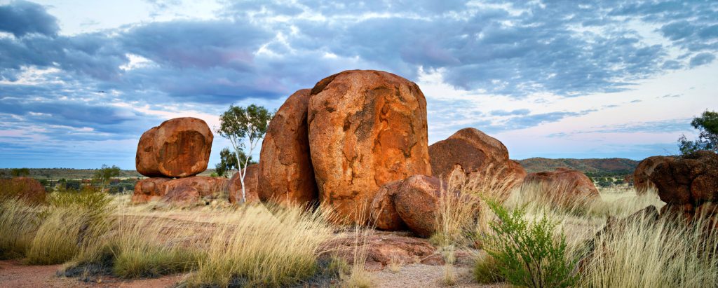
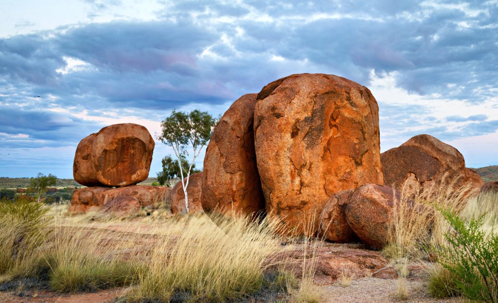
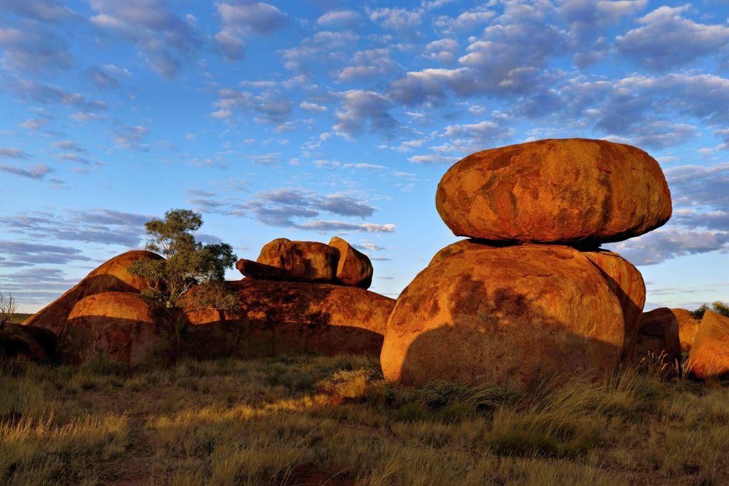
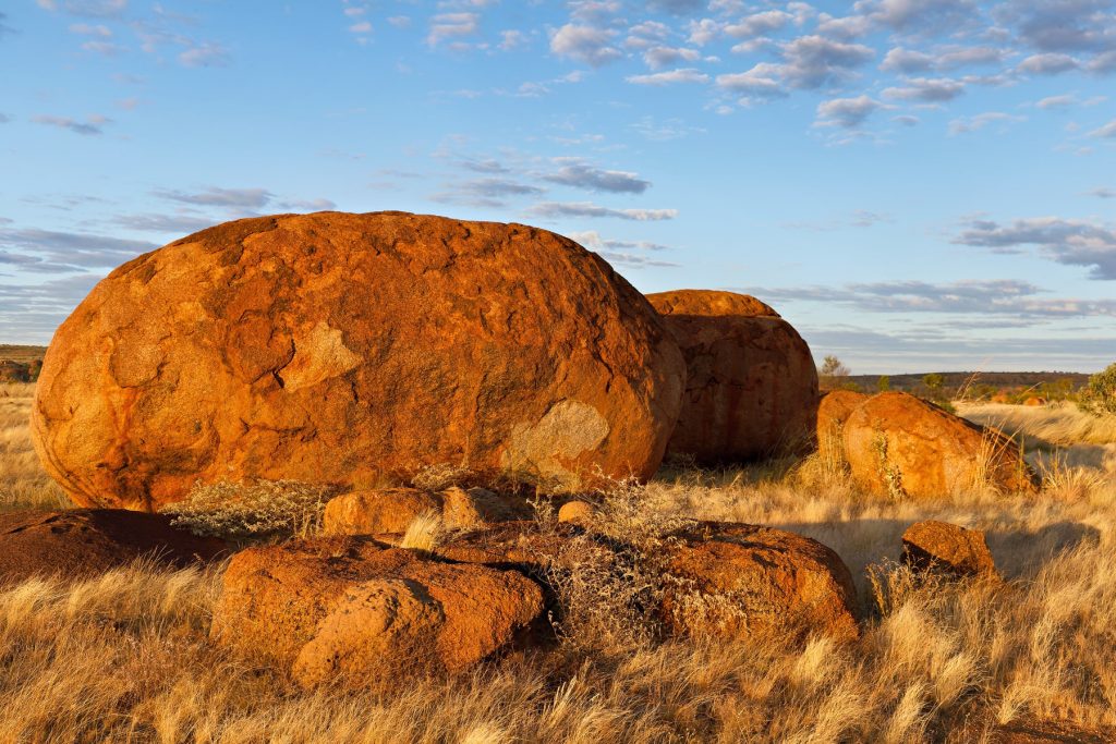
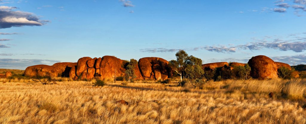
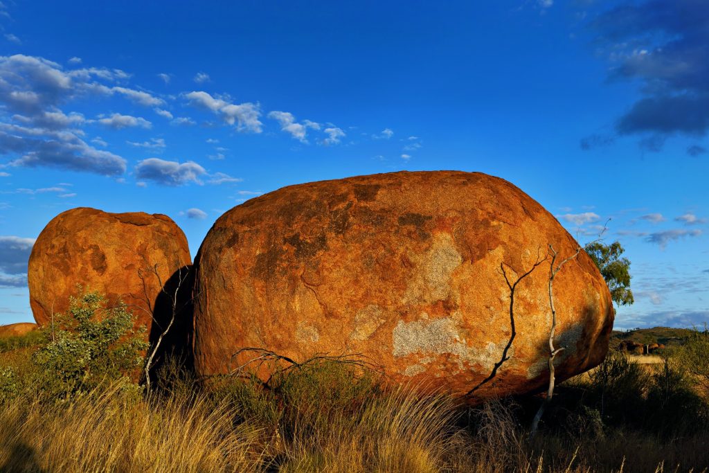
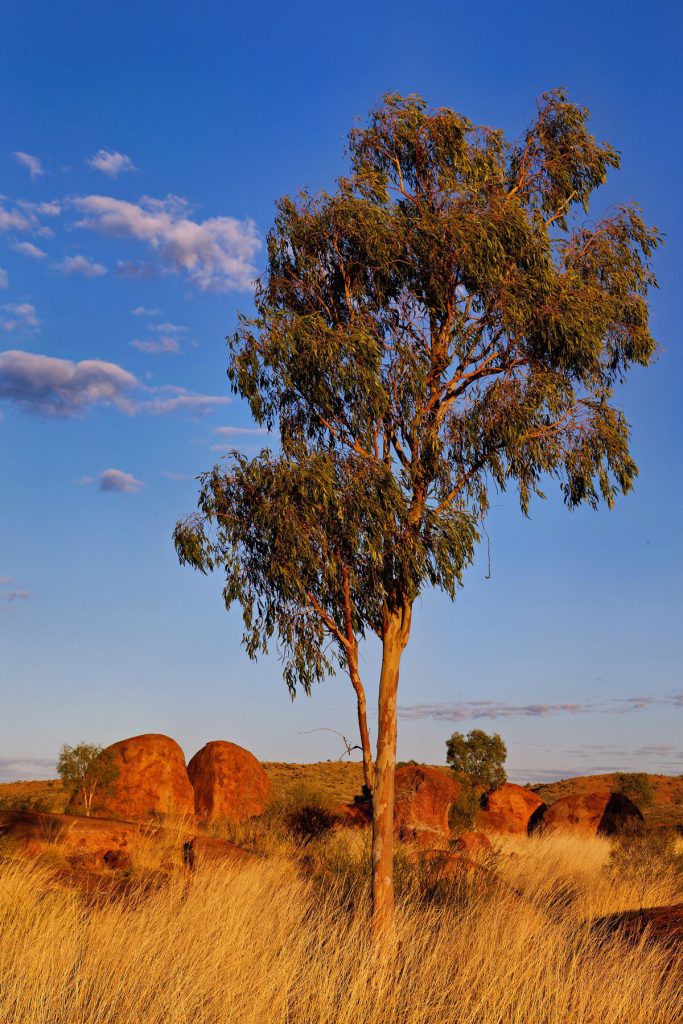
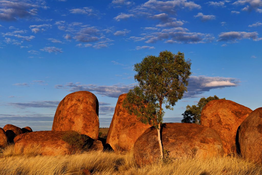
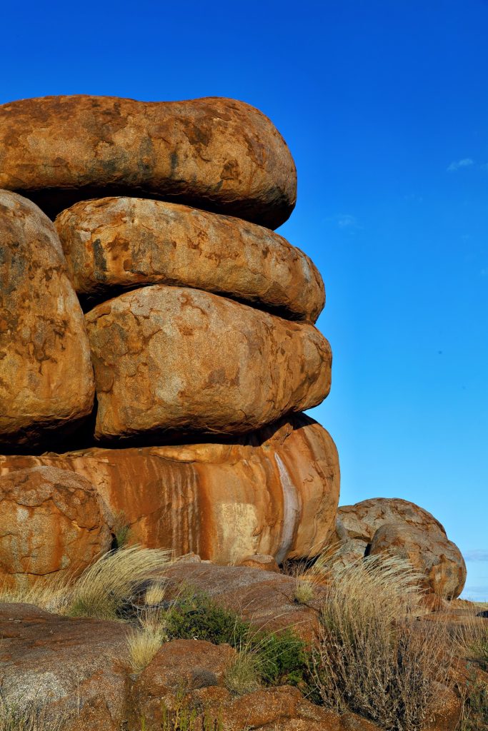
The Doc reprocessed some images from his Northern Territory trip, since he cannot travel due to treatment. This time the Devils Marbles south of Tennant Creek. A few image this time. Click on any image to see the slideshow, enjoy.
A superb all round experience. Amazing accommodation, great facilities, great food and support from both AWC Guides and Bullo River staff. The trip included bird watching, a morning river cruise, a guided helicopter trip, road trips around the Station and a last minute change in our arrival because of rain washing out the airstrip. We landed in Kununurra and were driven into Bullo River Station, down the Bullo River Access Road.
One place The Doc visited, on a helicopter trip around Bullo River Station, was Bullo River Gorge. More precisely, the part of the gorge known as Bull River Sands.
Earlier that morning, we had flown around the Bullo River and along the Victoria River to visit an AWC science team in the field, then we flew onto to Bullo River Gorge for breakfast.
The Bullo River starts and finishes on Bullo River Station, hence the Station’s name.
AWC runs the best supporter events, made even better when the Bull River Tourism team was involved.
A taste of what is coming. Enjoy.
Bullo River Sands, Bullo River Gorge, Bullo River Station
We were delivered in the bush taxi, a Robinson R44 helicopter landing in the gorge.
There was rain overnight at Bullo River Station, so planes cannot land on the unsealed air strip. Guests are leaving earlier from Darwin and being taken to a nearby air strip – that would be a country “nearby”. Kununurra has the nearest sealed airstrip.
Then Guests have a 3 hour drive into Bullo River Station, which has the longest driveway in the Northern Territory. The driveway is the hard left off the Victoria Highway on the map below. All part of the adventure, for me. Plus The Doc knows how to drive into Bullo River Station in the Grenadier!
AWC just works around the challenges to get us there. Thank you AWC.
The healthiest looking Dingo The Doc has seen in the bush, feeding off the rubbish dump at Innaminka in Outback South Australia. You can see rubbish in the background. Click on image to see full size.
The Bungle Bungle Ranges in the Purnululu National Park (The Kimberley) has the most extensive beehive rock formations in the world. While well known to local Aboriginals and Cattle Station owners, it did not become known to the world until the early 1980s.
Within 5 years it was a National Park and within 20 years it was World Heritage listed.
The beehives are formed by wind driven sand and rainfall (plus millions of years of weathering).
The beehive domes consist of different layers of sandstone; some orange, some black. The black layers hold more moisture allowing cyanobacteria growth which cause the black colour. The orange-coloured layers are stained with iron and manganese mineral deposits within the sandstone (in lay terms – rust!).
Typically, you see the domes from ground level. The Doc took a helicopter flight over The Bungle Bungles. The images are split into two groups; first, the rock formations out of which the beehives are weathered. Here you see deep gorges, meandering rivers (floodways now) and steep gorge walls. Second the domes or beehives themselves, from the air. Make sure you click on the pictures to see the full size images.
The Doc has been posting fewer images lately, but the Bungles deserves more to appreciate its stunning beauty.
In 2014 Tony and I travelled around outback NSW, Queensland and South Australia. Places like the Warrumbungles, Broken Hill, Marree, the ochre pits at Lyndhurst, ruins at Farina, Arkaroola Wildness Sanctuary, Innamincka, Brachina Gorge in the Flinders Ranges, Epsilon in outback Queensland, Cameron’s Corner, Tibooburra, Menindee Lakes and lots of others.
Characters like Talc Alf, roadtrains and huge coal carrying locomotives, the odd emu and even some water in this parched part of Australia.
Tony had a long chat with Talc Alf and enjoyed his stories (Alf was also the Outback postmen, talc carver, talc miner and general dogs’ body!).
Here is a map of the trip. The kink over Lake Frome near Arkaroola in SA was a plane flight we both took around Arkaroola. Doug Sprigg was the pilot and he thanked us all for financing his hobby (flying) when we returned. Lake Frome is the whitest salt lake in the world and is used by NASA to make various measurements.
Tony often spoke about the trip. He had photos on his phone he would show to nurses on his many trips to hospital. Tony is in five images below and I have written a little story around each one.
Coffee at the Innamincka Pub in SA
We had a shower at the public shower block – after being so remote for a few days a shower felt amazing.
Tony is drinking coffee before lunch. Then on to juicy steak sandwiches, chips and salad in the dining area. Then cake and ice cream for desert. The food was superb. The Innamincka Pub at the time was owned by the same people who owned the Birdsville Pub, Innamincka had better food IMO.
Tony also retained fond memories of the Innamincka Pub. We talked about it for years after.
Canonba near Nyngan Outback NSW
Tony sitting beside the car near his tent around 6.30am. My bed is in the Patrol.
We had refuelled and resupplied at Nygnan the previous afternoon and drove out to the free camping ground at Canonba. It was on the Canonba Road about 10kms out of the Nygnan township. Close by us in the camping ground was a wandering drover with his dogs (hidden by the Patrol).
Canonba was once an important Outback town when it was a supply depot for Cobb & Co coaches. Once the railway went through Nygnan, Canonba disappeared.
Middle of nowhere
Tony with the trailer gate down boiling the billy for tea. We had camped overnight in the middle of nowhere. The driver was tied. We camped beside the Wool Track between Ivanhoe and Cobar, NSW. It was an access road to the surrounding stations and not a single car drove past the whole time we were there.
Coally Station, Far North West NSW
Tony is leaning on the passenger’s seat setting up his camera. This was at a small ephemeral wetland off the Silver City Highway near Coally Station Homestead.
Earlier we had driven through Cameron’s Corner (fancy hamburgers for lunch that time, yum), then through Stuart National Park in the far north eastern corner of NSW.
Epsilon Station, Outback Qld
The image with Tony standing at the car door looking forward was near Epsilon Station in remote Outback Queensland. We were travelling out of the area on private roads used to service the Moomba Gas Field oil wells. Earlier we saw the white camel also pictured.
The road is called the Nappa Merrie-Santos Road. We were on the Santos end, Nappa Merrie Station (Ranch for any American readers) being at the other end. In remote Australia it is common to name roads after the destinations at each end, it sure helps you know where you are going.
How do I remember these details? First, I add keyword to my images. Second, I keep a travel diary to help indexing. Last, I add GPS co-ordinates to the images. Here I mainly used the GPS co-ordinates and memory.
Due to some medical issues with Tony (bruising mostly) the trip lasted only two weeks instead of the planned three weeks. Due to Tony’s limited mobility I was visiting places where I could drive Tony close to the scenery or eating place. It worked out well. I still remember those delicious BLTs (bacon, lettuce and tomato sandwiches) at the Blenheim Pub, Flinders Ranges. SA.
Click on the first image and a slideshow will appear. Take five minutes to look through the images.


You must be logged in to post a comment.